GIS for Telecommunications: Boosting Business Success through Spatial Intelligence
Imagine a world where telecommunication providers seamlessly optimize their networks, getting rid of idle resources and leaving no room for client dissatisfaction. This is the reality that can be achieved with the assistance of Geographic Information Systems, or GIS, where data serves as the catalyst for transformation.
In 2021, GIS breathed life into the telecommunications sector, generating a staggering $1.56 billion in revenue for communication service providers. But there is more to come. By 2030, the revenue is expected to increase by up to $4.48 billion! So, what drives this impressive growth?
At its core, the demand for GIS in the telecom sector lies in one pivotal force: the constant need for up-to-date information, which is paramount for strategic planning in a rapidly changing environment. Telecommunications networks, spanning vast geographies and generating immense amounts of dispersed data, benefit from GIS's ability to effectively manage and analyze this data.
At Flyaps, we've been assisting telcos in embracing new technologies and trends for over a decade. In this article, we have decided to share our knowledge about the immensely popular GIS technology among telcos and showcase real-life use cases of this innovation. Keep reading to learn more!
What is GIS in telecom
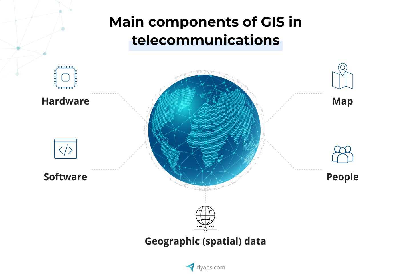
To be on the same page, let’s begin with a definition. GIS in telecommunications is a technology that combines computer hardware, specialized software, and geographic data to capture, analyze, display, and manage information with geographic references, also known as spatial data. Simply put, it's a system that helps organize and make sense of data by linking it to specific locations on a map.
For example, you want to expand your telecom company's network operations to provide better service to your customers. You have a map of your coverage areas, and you also have demographic data about your customers, location data about where your competitors have their towers, and geographical data about the terrain (like hills and valleys) in different areas.
With GIS software, you can take all this data and put it on one map. You can see where your network is strong and where it's weak. You can identify areas with a lot of customers but poor coverage and locations where a competitor's network might cause disruption.
A geographic information system also helps you make informed decisions. You can choose the best locations for new cell towers or decide where to upgrade your existing ones. This way, you can optimize your network, improve service quality, and keep your customers happy.
Let's delve deeper into how companies use GIS telecom for their business needs and the role it plays within the telecommunications industry.
Benefits of GIS in telecom and network services
There are many reasons why telecom companies are so eager to embrace GIS, and we're going to explore the most crucial ones.
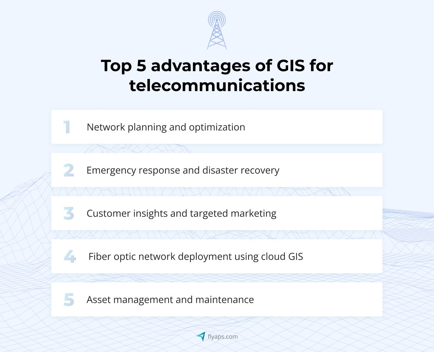
Network planning and optimization
Imagine a B2B telecom provider that struggles to optimize its network to meet the market demand for high-speed internet in urban areas. They employ GIS to analyze data on population density and traffic patterns in the city. The company overlays this information with their existing network infrastructure. Armed with this geospatial insight, the telco strategically deploys new cell towers and fiber optic lines in areas with the highest demand. The result is improved internet speeds and telecom infrastructure, leading to delighted business customers who experience fewer network issues.
Emergency response and disaster recovery
Suppose a major natural disaster happened, disrupting telecom network assets in a metropolitan area. You, as a telecom provider, have to respond quickly. You leverage GIS to integrate real-time data on the disaster's impact with their network infrastructure maps. By using GIS telecom, you quickly identify affected regions, ensuring that vital communication links are restored promptly. Hospitals, emergency services, and government agencies stay connected, aiding in effective disaster management and minimizing casualties.
Customer insights and targeted marketing
Imagine your telco wants to enhance its offerings for diverse business clients in different regions. You employ GIS to analyze customer data, segmenting it geographically, and tailor its service packages and marketing campaigns for each region. For instance, you offer data-heavy plans to tech startups in tech hubs and reliability-focused packages to manufacturing businesses in industrial areas. This personalized approach leads to higher customer retention and increased revenue.
From cloud migration to telecom-specific AI solutions, we have delivered over 20 projects that are used by hundreds of MNOs and telecom companies worldwide. Check our capabilities and let’s discuss your next solution.
See our servicesExplore our expertise in AI development platforms that power innovative telecom solutions.
Fiber optic network deployment using cloud GIS
Consider a scenario where a fiber optic provider encounters the challenge of expanding its network efficiently. They make the strategic decision to implement a cloud-based GIS platform for planning their fiber network. This approach optimizes the placement of fiber optic cables, resulting in reduced deployment costs and an accelerated expansion process. Consequently, the telco can offer businesses faster connectivity options, significantly enhancing their operational efficiency and data transfer speeds.
Asset management and maintenance
Many telecom providers can find it challenging to efficiently manage thousands of cell towers and equipment. The company implements GIS for asset management, which allows them to get real-time visibility into the status and location of each asset. Maintenance teams can proactively address issues, reducing downtime and operational costs, ensuring uninterrupted service for their clients.
In theory, it sounds promising, but how about in practice? Are there any real-life examples of telecom companies that have successfully embraced this trend and are already reaping the benefits of GIS in telecommunications? Absolutely, and they're not just any companies; they include well-known industry giants like Vodafone and T-Mobile Deutschland. Keep reading!
The use of GIS in telecom industry: real-life success stories
Let's examine real-life cases of well-known telecommunications companies and the GIS strategies they chose to enhance their business.
Vodafone's GIS-powered digital twin transforms network strategy

Vodafone, a leading European telecom company, has vast networks of cell towers and antennas to ensure connectivity. With technology advancing and infrastructure deteriorating, the construction of new mobile towers and the adjustment of existing ones is becoming more and more difficult. Vodafone was looking for a way to streamline this process and enhance efficiency for its engineers, and they opted for GIS technology.
Focusing initially on the UK region, Vodafone embarked on an ambitious project to create a national digital twin of its entire mobile mast network. This digital twin, an interactive and precise 3D model, enables engineers to strategize network improvements and expansions without physically visiting mast sites.
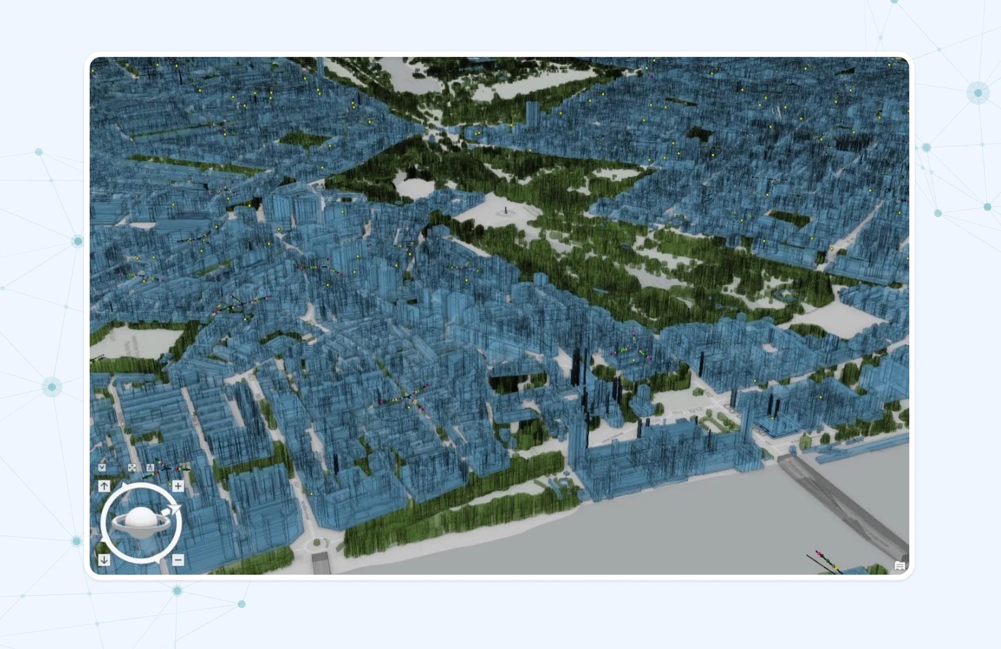
Creating this digital twin required vast amounts of data, leading Vodafone to deploy a platform that combines web mapping, real-time data handling, image analysis, and spatial data science. Satellite data was used to map the terrain, with a focus on accurately representing buildings and potential obstructions to the network performance.
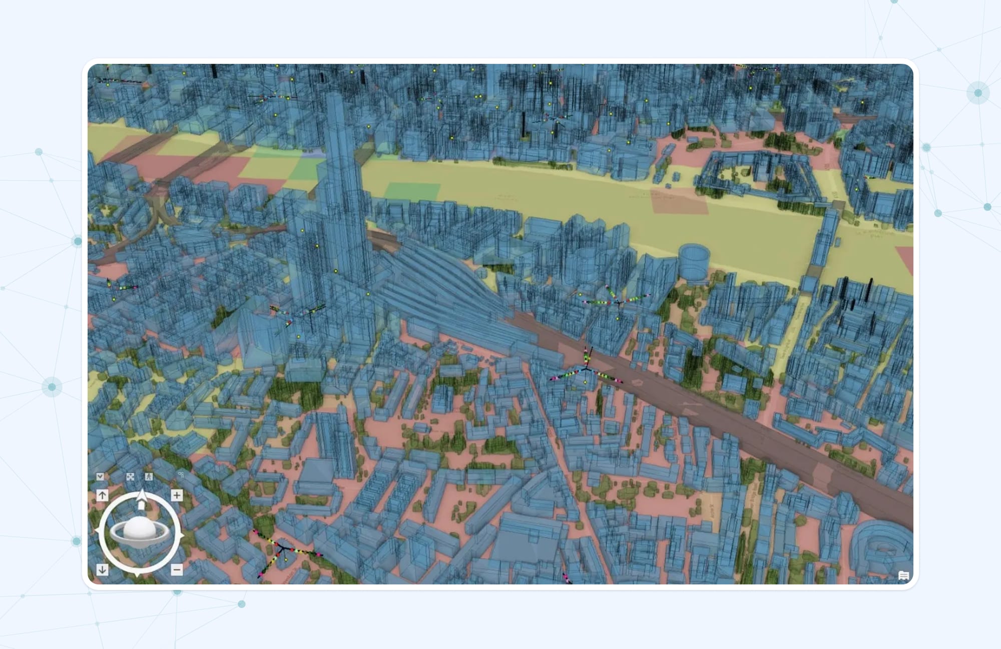
With the digital twin in place, Vodafone's engineers gained a powerful tool for making informed network decisions. The model provides precise information on the location of buildings, hills, valleys, and trees — factors that can interrupt or slow down connections between masts. Armed with this knowledge, Vodafone can now efficiently plan the placement of new mobile sites for optimal connectivity and identify areas requiring upgrades or repositioning. Additionally, the company reduces its carbon footprint by eliminating the need for physical site visits.
Vodafone is taking the digital twin idea to more countries, and they're using it to make their network even better. They want to add cool new features like Massive MIMO, which improve each cell site. This strategic move is in response to the anticipated growth of connected devices worldwide to 30 billion by 2025.
T-Mobile Deutschland's strategic use of GIS technology for network management

T-Mobile Deutschland, a part of German telecom giant — Deutsche Telekom AG, continually sought ways to improve its services and products. With over 4,000 customer service representatives spread across Germany, T-Mobile understood that the quality of its customer service would be a decisive factor in maintaining its competitive edge against other telecommunications service providers.
Another crucial area they were looking to improve was the quality and efficiency of mobile radiotelephone networks. Simultaneously, geodata has gained recognition for its role in meaningful industry analysis. So, T-Mobile recognized the value of an internet-based spatial information system and was eager to use it to enhance these two crucial areas.
To achieve these goals, T-Mobile decided to develop a tailored system for T-Mobile's intranet, leveraging a geodata server. This server's data and functionalities were seamlessly integrated into specialized applications, enhancing their analytical capabilities.
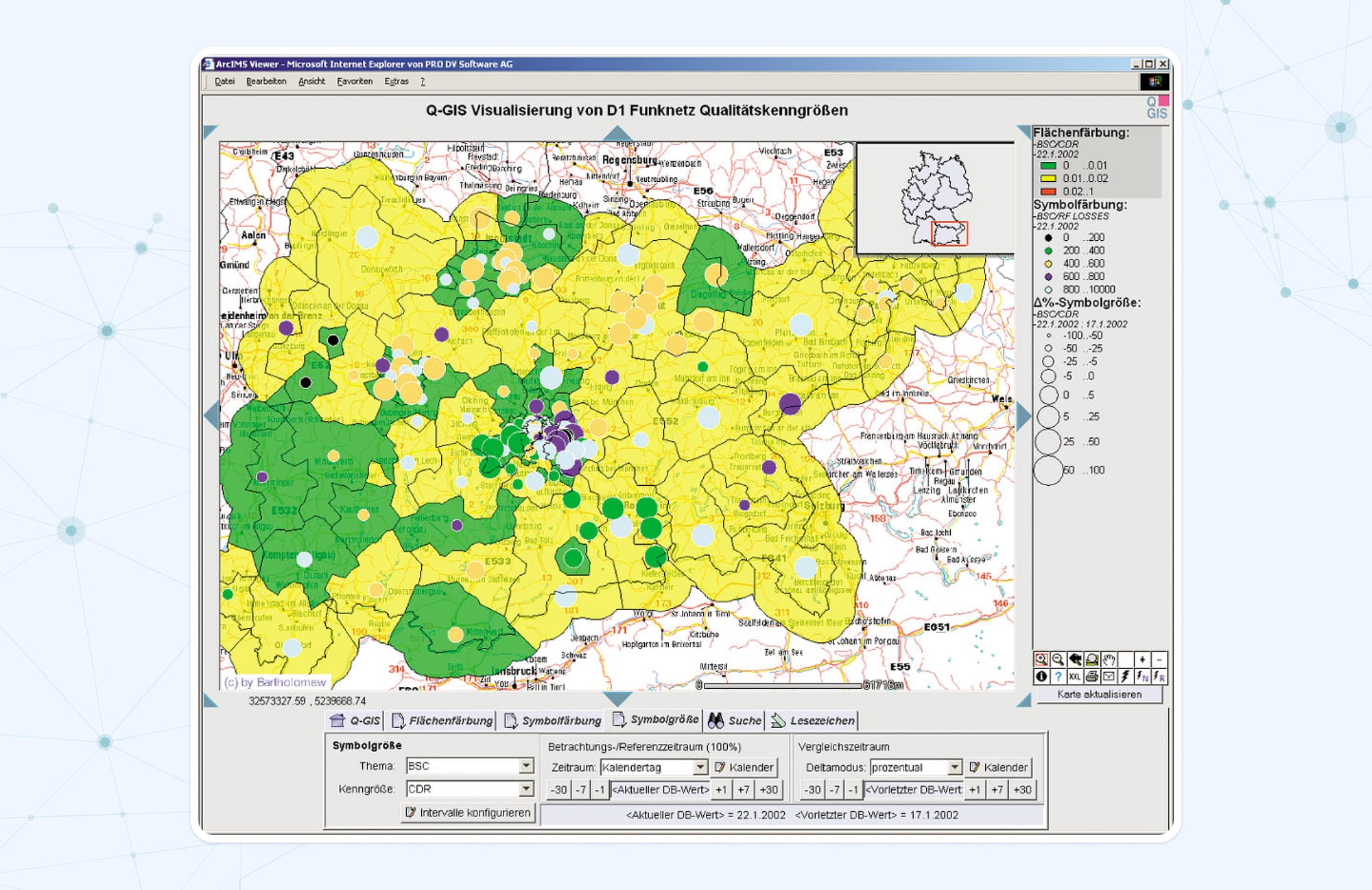
One application within the system was Q-GIS, a geodata server-based solution. Q-GIS allowed T-Mobile to analyze the quality of its T-D1 network across various spatial and chronological scenarios, enabling inquiries about factors such as mobile switching center workloads in cities or base transceiver station performance during major events like Formula 1 races. The results of up to three inquiries could be visualized on a single map, providing valuable insights at a glance.
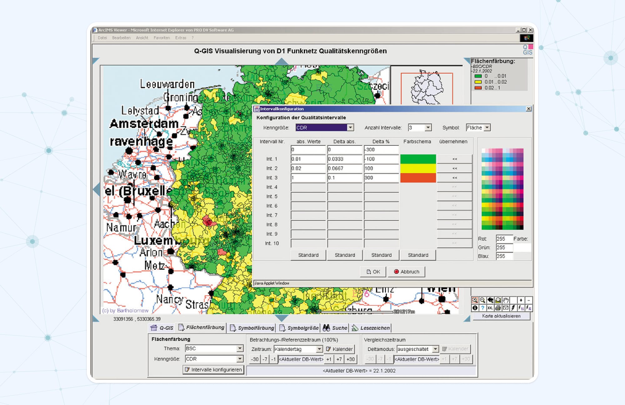
The system was designed for use within T-Mobile's intranet, utilizing modern database management system (DBMS) techniques and optimized SQL inquiries for automatic daily data processing and fast online calculations.
The system relied on daily measurements collected by T-D1 mobile radiotelephone antennas throughout Germany, generating millions of data records daily. These measurements included direct values from individual cells, spatially aggregated values from cell groups, and chronologically aggregated values. The system's flexibility allowed for the introduction of new parameters and calculation formulas.
T-Mobile Deutschland's adoption of GIS technology transformed its network management capabilities. By harnessing the power of spatial data and visualization through Q-GIS, T-Mobile achieved improved network quality, optimized efficiency, and empowered its customer service representatives to deliver top-tier service. This innovative approach not only elevated customer satisfaction but also strengthened T-Mobile's competitive position in the dynamic telecom industry.
How Flyaps can help you with telecom GIS
As a trusted technology partner, Flyaps offers a comprehensive suite of services designed to streamline your geographic information system implementation and elevate your telecom business to new heights.
Network planning and deployment
At Flyaps, we understand that an efficient and well-optimized network is the backbone of any successful telecom operation. Our team of experts can utilize GIS technology to help you strategically position infrastructure components for optimal coverage and capacity. Whether you're expanding your network or upgrading existing systems, our tailored solutions ensure that you make data-driven decisions, leading to improved service quality and expanded coverage.
Operations and maintenance services
We recognize the importance of network reliability and uptime in the telecom industry. That's why we offer operations and maintenance services that leverage GIS to monitor and manage your network in real time. From proactive maintenance to swift issue resolution, our solutions are designed to minimize downtime, enhance network performance, and improve overall operational efficiency.
Custom GIS-powered solutions development
Flyaps can craft tailored solutions that utilize geospatial data to its fullest extent. Whether it's analyzing customer demographics, optimizing network resources, or enhancing targeted marketing efforts, our GIS-powered solutions will match your telco's needs.
Looking to harness the power of geographic information systems to transform your telecommunications operations? Drop us a line!
 Flyaps